For information on the Waterfront Regeneration Trust’s Maps, click here.
Publications
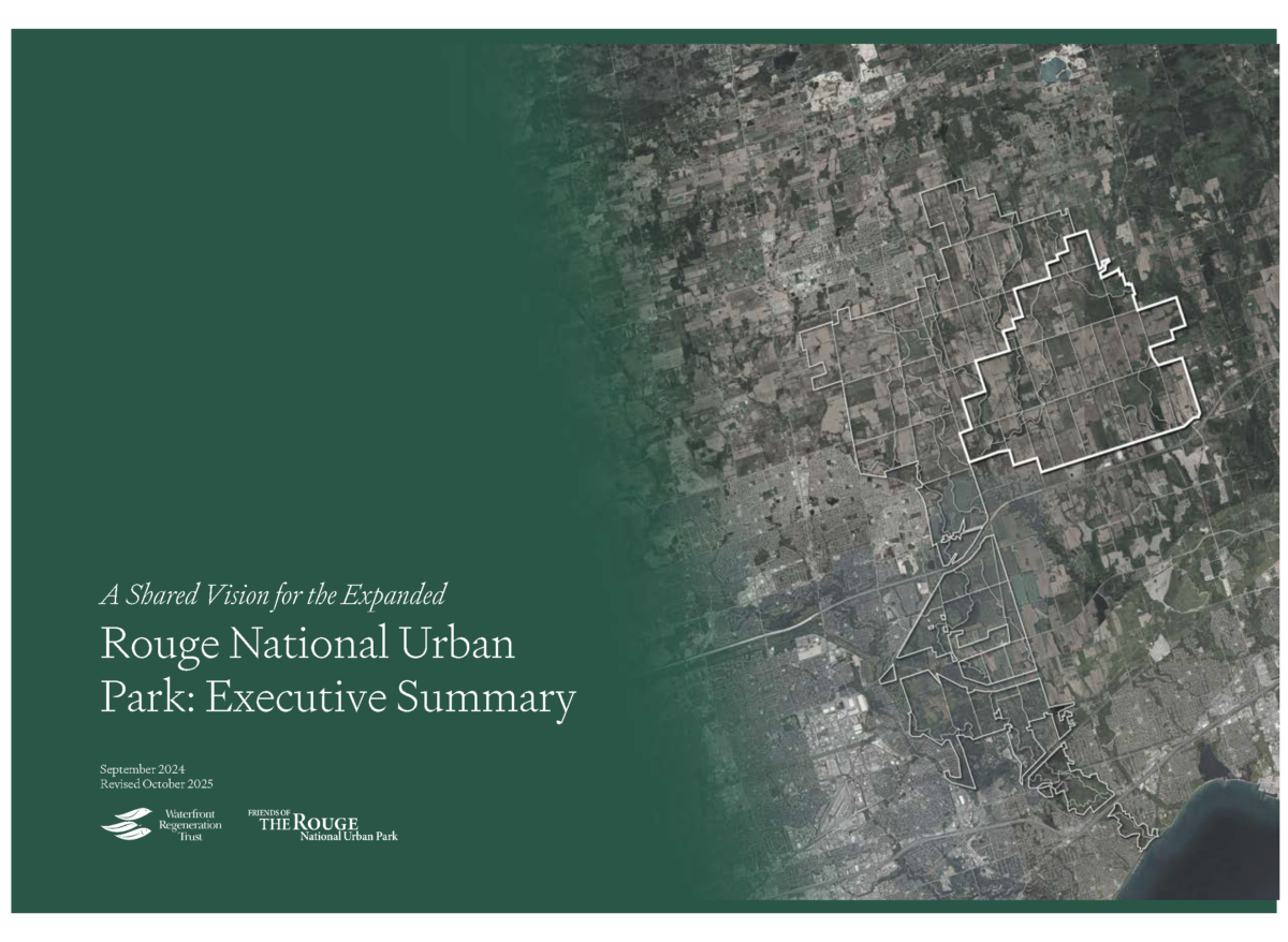 BACKGROUND
In 1972, the Canadian government expropriated 18,600 acres (7,527 hectares) of land in North Pickering for an international airport that was never built. Over the 50 years that the project has been on hold, the lands have not been used to their maximum economic potential, while surrounding communities and ecosystems face significant pressures for urbanization. This presents an extraordinary opportunity to integrate these lands into the Rouge National Urban Park (RNUP), Canada’s premier urban park. Currently, these lands contain a diverse mosaic of ecosystems, including the Duffins Creek watershed and some of Canada’s best agricultural land.
OPPORTUNITY
If the threat of the airport on the Pickering Federal Lands is removed, it opens a unique one-time opportunity to leverage this vast area, incorporating these lands into the expanded RNUP. This would allow for the creation of a world-class model of coexistence between nature, farming, and rural communities, simultaneously addressing environmental conservation, agricultural sustainability, and rural revitalization.
Such integration could be one of the last large-scale land transfers in southern Ontario, bringing multiple benefits to the region while safeguarding the area’s ecological and agricultural value. The ecosystem services that nature provides are our ‘natural capital’. Without their irreplaceable functions such as pollination, climate regulation, soil health, and water filtration, we will be jeopardizing our future food security, and there will be no negotiation in the world that will bring that back.
VISION
At the heart of this vision is the preservation of prime Class 1 farmland, which is among the most fertile in Canada, alongside natural ecosystems that support a rich variety of flora and fauna, protecting these resources while enhancing them through sustainable farming practices, agritourism, and community revitalization. This vision builds on the area’s historical significance, including farming legacies and heritage structures, while looking toward future sustainability. By bringing together these elements, the expanded park will serve as a demonstration of how environmental and agricultural goals can align for mutual benefit.
The expanded RNUP will serve one of Canada’s most densely populated urban regions, providing essential green space for millions of residents. It would allow urban dwellers to engage with nature, learn about the region’s natural and cultural heritage, and participate in outdoor recreation. Additionally, it will create opportunities for agritourism and agri-businesses, boosting local economies and providing sustainable livelihoods for farmers and entrepreneurs.
This expansion also strengthens the ecological connection between the Oak Ridges Moraine and Lake Ontario, two critical natural features in the Greater Golden Horseshoe. By maintaining an intact ecological corridor, wildlife will continue to move freely, ensuring the long-term health of ecosystems across the region.
ACTION
The primary goal is to transfer ownership of the Pickering Federal Lands from Transport Canada to Parks Canada. This transfer will secure the area’s natural and agricultural heritage and foster community revitalization. By integrating the lands into RNUP, this initiative will also contribute to Canada’s broader environmental goals, such as conserving 30% of the country’s land and waters by 2030 as part of its Global Biodiversity commitments. In conclusion, this Shared Vision for the Expanded Rouge National Urban Park incorporating the Pickering Federal Lands into RNUP represents an unparalleled opportunity to address some of the region’s most pressing environmental, agricultural, and community challenges. By demonstrating how nature, farming, and rural communities can thrive together, this expansion offers a forward-thinking solution for the 21st century.
A Community-Driven Land Trust for the Pickering Federal Lands would ensure that publicly owned lands are held in perpetual public stewardship, managed for community benefit rather than private speculation. By empowering local residents, public partners, and civic organizations to guide development, the trust would restore the hamlet of Brougham and create a new vibrant, mixed-use hamlet that embody social inclusion, ecological regeneration, and long-term public accountability.
In conclusion, this Shared Vision for the Expanded Rouge National Urban Park incorporating the Pickering Federal Lands into RNUP represents an unparalleled opportunity to address some of the region’s most pressing environmental, agricultural, and community challenges. By demonstrating how nature, farming, and rural communities can thrive together, this expansion offers a forward-thinking solution for the 21st century.
RECOMMENDATIONS
1. Transfer all government-owned lands in the Pickering Federal Land holdings to Parks Canada for the expansion of the Rouge National Urban Park to ensure their protection and management under Parks Canada’s mandate. Any lands within the Park designated as urban settlement should remain under Park Canada’s oversight and protection, and be managed through a community-driven land trust model.
2. Parks Canada to undertake a public process and Indigenous and First Nations consultations to refine the vision for the future of the Pickering Federal Lands within the expanded Rouge National Urban Park.
3. Increase funding to Parks Canada to implement the expansion and manage the expanded RNUP.
Pickering Federal Lands Benefits Assessment
HR&A Consultants
March 2026
This briefing book informs a once-in-a-generation land use decision by outlining the benefits of an integrated approach to the future of the Pickering Federal Lands—grounded in the Shared Vision for the Expanded Rouge National Urban Park—as well as the implications of a fragmented approach to land use planning.
 Regeneration: Ontario’s Waterfront and the Sustainable City
The Hon. David Crombie, Founder, Waterfront Regeneration Trust (1992)
“It is difficult to imagine a time of greater need for waterfront regeneration and a better opportunity to do it right.” Twenty-five years after the publication of Regeneration, the truth of this statement endures. Regeneration is the final report in which the Honorable David Crombie recommends ways to regenerate what he called the Greater Toronto Bioregion. The work of the Royal Commission on the Future of the Toronto Waterfront highlights the links that exist between city and nature – among people, the economy, health, and environmental sustainability. It promotes the ecosystem approach to achieve both environmental regeneration and economic recovery. It suggests new ways of doing things; round-table processes to bring agencies, the public, and business together; integration of environmental and land use planning; and partnerships to get things done.
Regeneration suggests ways to regenerate the waterfront by:
– Cleaning up the rivers and Lake Ontario;
– Establishing greenways and trails throughout the bioregion;
– Protecting and restoring habitats;
– Enhancing sense of place through historical connections, social diversity, attractive vistas, and good design;
– Stimulating the regional economy through new green infrastructure, environmentally friendly enterprise, transportation, and waterfront housing.
Contents, Preface & Introduction (pp i-1)
Part I: Planning for Sustainability
Chapter 1 – The Ecosystem Approach (pp 19-61)
Chapter 2 – Planning Practice (pp 63-94)
Part II: Environmental Imperatives
Chapter 4 – Shoreline (pp 149-176)
Chapter 5 – Greenways (pp 177-206)
Chapter 6 – Winter Waterfront (pp 207-223)
Healing An Urban Watershed: The Story of the Don (pp 225-258)
Part III: Places
Chapters 7, 8 & 9 – Halton, Mississauga & Etobicoke (pp 261-302)
Chapter 10 – Central Watershed (pp 303-414)
Chapters 11 & 12 – Scarborough & Durham (pp 415-453)
 Ontario Greenway Strategy
Waterfront Regeneration Trust (1995)
Ontario Greenway Strategy, May, 1995
A great deal of progress has been made since the Royal Commission on the Future of Toronto’s Waterfront began its work in 1988 – progress in implementing specific projects; significant improvements in provincial and municipal policies; and changing the way communities view their waterfront. The Lake Ontario Greenway Strategy reports on this progress and establishes a consensus-based blueprint for further actions. It provides a context for setting priorities, guidance on ways to achieve a shared vision and an information base to assist decision-making.
The Strategy provides an overview of background and context, a description of the key features of the waterfront of today, an analysis of the objectives and actions necessary to realize the waterfront of tomorrow, and an overview of implementation mechanisms and roles. The goal of the Strategy is to foster commitment to actions that will regenerate a healthy and sustainable waterfront that is clean, green, accessible, connected, open, usable, diverse, affordable and attractive. This goal is supported by five objectives, and a series of actions necessary to achieve each objective.
Includes:
– Colour Maps
– Photographs
– Listing of waterfront natural core areas and corridors
– Glossary and acronyms
– Bibliography and toolkit
 Restoring Natural Habitats
Hough Woodland Naylor Dance Ltd. And Gore & Storrie Ltd. (1995)
Restoring Natural Habitats (1995)
Restoring Natural Habitats is a manual for habitat restoration in the Greater Toronto Bioregion. It provides the information you need by guiding you through five easy steps to restoring habitats. Restoring Natural Habitats details how to assess the potential and significance of your site, what species are appropriate, and how to involve your local community. Diagrams and photos explain techniques and illustrate examples of restoration in progress for the most common habitat types in the Greater Toronto Bioregion of southern Ontario.
 A Decade of Regeneration: Realizing a Vision for Lake Ontario’s Waterfront
Suzanne Barrett, (2000)
A Decade of Regeneration: Realizing a Vision for Lake Ontario’s Waterfront. Barrett, S. (2000)
A Decade of Regeneration is about our special relationship with Lake Ontario, and the remarkable progress that is being made by thousands of people dedicated to the Lake Ontario Greenway. The book brings attention to waterfront excellence and celebrates waterfront heritage as a reflection of buildings and culture, ideas and tradition and of the connections between people and nature.
With a myriad of examples, A Decade of Regeneration documents intitiatives large and small where trails have added measuable value, where creative partnerships and funding have resolved an apparent gridlock, and where excellence in design has elevated a typical project into a piece of art and heritage. A Decade of Regeneration sets a new direction for the next decade of regeneration to capture the momentum and renew our commitments.
 Waterfront Trail Design, Signage & Maintenance Guideline Update
Victor Ford Associates Inc. (1997), Update by Marshall Macklin Monaghan (2007)
Waterfront Trail Design, Signage & Maintenance Guideline Update
The Design, Signage and Maintenance Guidelines were developed to assist in constructing and signing new Waterfront Trail sections, and managing existing sections, but many elements apply to any trail.
The MMM Group revised and updated the Guidelines in 2007 to reflect current information and best practices from across North America and internationally. The 2007 update contains an expanded section covering options and guidelines for on-road sections of Trail, as much of the Trail currently follows on-road routes.
The Guidelines include helpful advice on how to:
- Plan for the differing needs of pedestrians, cyclists, in-line skaters and people with disabilities;
- Identify appropriate widths, surfaces and grades for off-road and on-road trails;
- Minimize the potential impact of trails on wildlife and habitat;
- Choose signs that help trail users to find their way easily and safely;
- Manage maintenance tasks so that everyone gets maximum enjoyment out of the trail;
Community groups, trail clubs, municipal and parks staff, landscape designers and others will all find these Guidelines helpful both for managing existing trails and for building new ones.
Waterfront Regeneration Trust Report Library
 CYCLE TOURISM & CYCLING ACTIVITY SURVEY REPORT, November 2020
In November 2020, the Waterfront Regeneration Trust and Transportation Options, in partnership with the Greenbelt Foundation surveyed 904 cyclists about their cycling in 2020 and plans in 2021. The purpose of the survey was to assist tourism partners, tourism businesses and related organizations to understand impact of COVID-19 on cycle tourism and cycling activities.
- Assist tourism partners, tourism businesses and related organizations plan for future cycle tourism and cycling activities post COVID-19.
- Provide insight and information for planning purposes on the Great Lakes Waterfront Trail and the Greenbelt Route.
The survey was launched mid-October and closed at the beginning of November, 2020. A total of 904 respondents completed the 20 question survey. Over 300 additional comments were provided.
This survey builds on a similar survey conducted in May 2020, and report which can be found at here.
 CYCLE TOURISM & CYCLING ACTIVITY SURVEY REPORT, May 2020
In May 2020, one and half months after the province announced travel restrictions in response to the pandemic, the Waterfront Regeneration Trust and Transportation Options, in partnership with the Share the Road Coalition surveyed 885 cyclists about their cycling in 2020 and plans in 2021. The purpose of the survey was to assist tourism partners, tourism businesses and related organizations to understand impact of COVID-19 on cycle tourism and cycling activities.
- Assist tourism partners, tourism businesses and related organizations plan for future cycle tourism and cycling activities post COVID-19.
- Provide insight and information for planning purposes on the Great Lakes Waterfront Trail and the Greenbelt Route.
This survey is complemented by a similar survey conducted in Fall 2020, and report which can be found at here.
 Strategic Plan Summary, Summer 2014
A summary of the Waterfront Regeneration Trust Strategic Plan is available here. Click here to download a summary of our Strategic Plan.
 Land Use Planning Survey
Land Use Planning Survey, 2014
A 2 page summary of the Landuse Planning Survey is available by clicking here.
Ann McIlroy’s power point presentation
The Waterfront Regeneration Trust and Brook McIlroy undertook a Land Use Planning Survey of the planning commissioners in communities along Lake Ontario and the St Lawrence River in December 2013 – January 2014.
The Waterfront Land Use Planning Survey was developed to document and improve understanding of the current policy framework shaping the management and enhancement of our shared waterfront. The survey shares and promotes experiences, successes and challenges among partners to strengthen the goal of protecting and enhancing Ontario’s waterfronts. In addition, four case studies were conducted on Oshawa, Prescott, Grimsby and Mississauga. Each of these communities has a different experience with waterfront land use planning and policy development, offering lessons with other municipalities.
Some key findings:
- Waterfront visions continue to emphasize public access and the other nine waterfront principles of the Regeneration. The majority of respondents indicated their communities had articulated a vision for the waterfront (82%) and for public waterfront access (89%). Just over half (55%) articulated a specific vision for the Waterfront Trail.
- Majority of respondents are currently undertaking projects to enhance the waterfront (63%) and Waterfront Trail (57%).

Waterfront Trail User Survey
Ritter, D., Rendle, N., and Coughlin, R. (2002)
During the summer of 2002, the Waterfront Regeneration Trust and the waterfront municipalities and conservation authorities set out to investigate how user perceptions about the Trail had changed from the previous user survey completed in 1996. The 2002 survey gathered data that addressed the economic, recreational, and potential tourism benefit of the Trail.
Some key findings include:
– 95% of users surveyed support a continuously linked trail from Niagara-on-the-Lake to Gananoque,
– 77% of users view the Trail as a potential vacation destination, and
– 99% of users would recommend the Trail to other people.
The results of this study will assist the Waterfront Trust and its local partners to continue to design a Waterfront Trail that delivers safe and enjoyable recreation experience and that future projects and extensions to the Trail are planned and implemented successfully.
 Lower Don Lands Strategy: Flood Protection and River Regeneration Concepts (July, 1994)
The Lower Don Lands is described in Regeneration (the report of the Royal Commission on the Future of the Toronto Waterfront) as including the west and east sides of the Lower Don, the East Bayfront, the former Ataratiri lands, the Gooderham and Worts site, the Port Industrial Area, the Outer Harbour, the Leslie Street Spit and the parklands of Ashbridge’ s Bay. The present study of River Regeneration and Flood Protection Concepts addressed these lands but focused most closely upon the area covered by the first five places in the list. These are essentially the areas affected by the flood plain of the lower Don River.
 Watershed: Interim Report
The Hon. David Crombie, Founder, Waterfront Regeneration Trust (1990)
Watershed: Interim Report, August 1990
Watershed is the second interim report of the Royal Commission on the Future of the Toronto Waterfront. It includes 80 recommendations to ensure that the future of the waterfront – from Burlington to Newcastle, from the shores of Lake Ontario to the northern reaches of the Toronto watershed – is consistent with the Commission’s principles: that the waterfront be clean, green, useable, diverse, open, accessible, connected, affordable, and attractive.
 Interim Report, Summer 1989
The Hon. David Crombie, Founder, Waterfront Regeneration Trust (1989)
On March 30, 1988, the federal government appointed the Honourable David Crombie to act as a one-person Royal Commission to study the future of Toronto’s waterfront in light of Toronto’s history, values, and contemporary issues. Over a period of six months, the Royal Commission held a series of public hearings; more than 300 groups and individuals came forward with submissions that illustrated people’s profound interest in the future of their waterfront. The Interim Report highlights the recommendations that resulted from research studies and public hearings. The report also examines the role and mandate of the Toronto Harbour Commissioners; the future of the Toronto Island Airport and related transportation services; the issues affecting the protection and renewal of the natural environment insofar as they relate to the federal responsibilities and jurisdiction; the issues regarding the effective management of federal lands within the Toronto waterfront area; and the possible use of federal lands, facilities, and jurisdiction to support emerging projects.
What purposes should our reclaimed waterfront serve? What should it look like? What should it become? A place to live? A place to work? A play to play? A combination of all of these? Only two of them? In what ratios? What proportion? What scale? What kind of work? And so on. In answering these questions, citites define themselves…The people of Toronto instinctively understand this. They understand the importance of what is being done on their waterfront today….they will accept nothing less than the best we can do–that they want it done right. That chance to do it right will not come again for a long time. –Introduction
