
The Great Lakes Waterfront Trail is the beginning of many wonderful regional loops created by our community partners. While cycling is the chief trail use, there are some wonderful hiking experiences as well. Some of our favourites are listed below.

Cornwall and Counties of Stormont, Dundas and Glengarry
Approximately a 5hr drive east of Toronto, Cornwall and SDG have created 19 cycle routes (loop and out and back) to showcase the region’s culinary specialties, craft alcohol, heritage and landscape. Ranging from 10 to 72 km, there is something for everyone. Routes 2, 4, 8, 10, 11, 13, 14, 15 and 17 use the Great Lakes Waterfront Trail. Download Ride with GPS routes or the pdf map guide.


Hamilton – HamBur Loop
The Great Lakes Waterfront Trail in Hamilton and Burlington now includes the HamBur Loop, a 50 kilometre route offering recreational cyclists a great touring option for taking in some of the area’s most stunning waterfronts and scenic lookouts. Using mainly pathways, rail corridors and gravel trails, the route is perfect for bikes with wider touring or hybrid tires. Cycle-friendly restaurants and hotels are conveniently located right on the route, making it easy for the not-so-serious cyclist to explore the route over a few days at a more leisurely pace. See pages the maps below.

Lennox Addington County (Greater Napanee, Loyalist)
About 2 hours from Toronto and Ottawa and 3 hours from Montreal, L&A County Trails include twelve well-marked and easily accessible looping routes with 600 km of paved roadway. Using the Waterfront Trail are: B-Napanee River (24km), D-Shoreline Route (71 km), E-Hay Bay (44km), K-Amherstview (24km).
http://www.lennox-addington.on.ca/explore/county-trails [Lake Ontario and Hay Bay]

 Northumberland County
(Port Hope, Cobourg, Alnwick/Haldimand) –about 90 minutes east of the Toronto area. Rolling hills, pristine forests and crystal clear waters make Northumberland County a natural – a top outdoor adventure destination. There’s so much open space to explore. We’ve got the meandering cycling trails and routes to prove it.
www.NorthumberlandTourism.com/CyclingLoops [Lake Ontario and Rice Lake]

Durham Cycle Tours
14 fantastic cycling loops that include the Great Lakes Waterfront Trail (off-road from Pickering to Oshawa!) and the Greenbelt Route. It describes over 700 km of cycling! Download GPS and PDF versions of the map at https://www.durhamtourism.ca/cycletours.
Hikers will love the Durham Region Trails Guide filled with great walks in the Durham area including the Trans Canada Trail and Great Lakes Waterfront Trail. Check out the interactive map here. http://image.durham.ca/TrailsMap/default.html

Niagara and Greater Niagara Circle Route
140km loop that follows Lake Ontario, the Niagara River, Lake Erie and the Welland Canal system. Check out Niagara Cycle and Stay–a group of B and Bs who will move your gear ahead to the next stop. Visit the Niagara Cycling Tourism Centre for info on routes, accommodations, rentals
https://www.niagararegion.ca/government/initiatives/gncr/

Essex County and Windsor
Tourism Essex Windsor Pelee Island developed an excellent cycle tourism map for the region which offers several excellent riding itineraries in the area: https://visitwindsoressex.com/wp-content/uploads/2019/06/cyclingmapv3.pdf
Essex County-wide Active Transportation Cycling Map: https://www.countyofessex.ca/en/discover-the-county/cwats-maps.aspx. An excellent printed map is also available at local recreation centers, municipal offices, and libraries.
Essex County- https://www.essex.ca/en/discover/Cycling.aspx


Haldimand County
About 90 minutes west of Toronto. Six looped routes take throughout scenic Haldimand– provincial parks, conservation areas, Lake Erie and the Grand River. The following routes include the Great Lakes Waterfront Trail: Yellow-Lowbanks Tour (47km loop), Blue-River Route (69km loop), Orange-Lakeview Tour (70 km) and Teal-Great Lakes Waterfront Trail (95 km linear). The map shows parking, washrooms, restaurants.
https://maps.haldimandcounty.on.ca/extra/cycling/
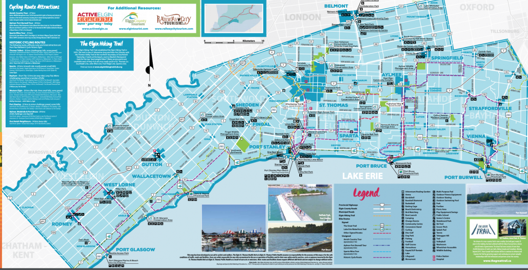
Elgin County
Explore the beautiful trails and parks by biking, walking, hiking, jogging, and cross-country skiing throughout Elgin County. The comprehensive map shows over 5 cycling loops that include the Great Lakes Waterfront Trail along Lake Erie. For more information and to order your map, visit: http://www.elgintourist.com/cycling.
St. Thomas and Four Ports Tour
This four-day journey, takes you along quiet rural roads and the Waterfront Trail, down Lake Erie’s northern shoreline and through four heritage fishing ports and expanses of farmland. For more information visit: http://www.elgintourist.com/cycling.
Total Distance: 184 km. See the map.
Windsor-Essex Featured Binational Tourism Loops
The Gordie Howe International Bridge connects trail networks in Canada and the United States, linking the Great Lakes Waterfront Trail and Trans Canada Trail in Windsor with the Great Lakes Way and Iron Belle Trail in Detroit.
This collection of signed and unsigned routes connected to the Gordie Howe International Bridge in Windsor, ON, the Great Lakes Waterfront Trail and Trans Canada Trail are the product of a partnership between the WRT, TCT, Tourism Windsor-Essex- Pelee Island, Share the Road Essex, local communities in Canada and the U.S. and the Detroit Greenway Coalition.
Each route can be viewed on Ride with GPS in the collection below.
Sandwich Town Loop | 12 km, Signed
Ride from Malden Park to the Gordie Howe International Bridge and historic Sandwich Town, one of the oldest settlements in Ontario. Features several historically significant events and sites which represent the storied past of Sandwich Town.
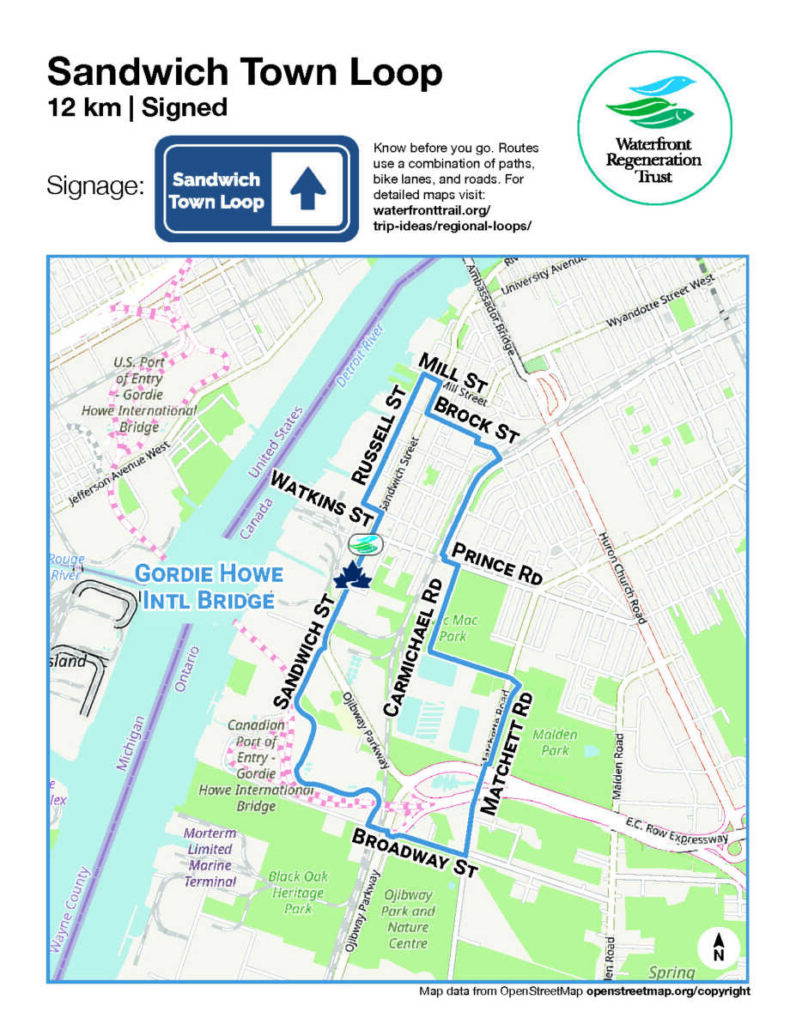
Click here to download the overview map.
Parkway Trail | 60 km, Signed
An exploration of south Windsor, the Town of Essex, and Lasalle. Featuring the Rt. Hon Herb Gray Parkway Trail, the Chrysler Greenway, Laurier Parkway Trail, and scenic rural roads, you’ll take in the sights and visit an outdoor gallery depicting the challenges and triumphs of Essex.
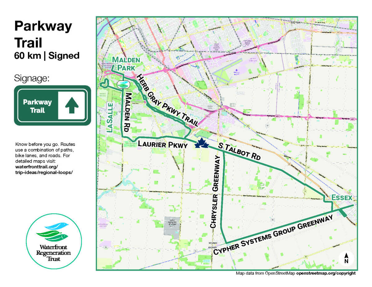
Click here to download the overview map.
Heritage Waterfront Trail | 59 km, Signed
Traverse Essex County riding the Cypher Systems Greenway Trail, Chrysler Canada Greenway, and the sunny Lake Erie shoreline. Take in a storied past in Amherstburg, accompanied by historic architecture, natural wildlife, a pristine shoreline, and the beach at Holiday Beach Conservation Area overlooking Lake Erie.
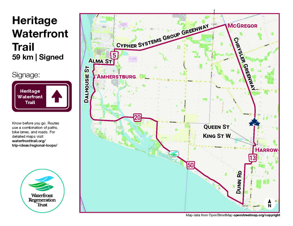
Click here to download the overview map.
Wine Trail| 44 km, Signed
Escape to the Essex Pelee Island Coast for award-winning wineries, sight-seeing opportunities, attractive beaches, friendly bicycle tours, and unique shops. Find your own pace down Country Road 50 on sunny, bike-friendly terrain, and enjoy eclectic bites, brews, boutiques, and shops along the way.
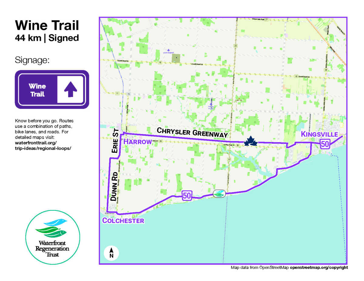
Click here to download the overview map.
The Windsor Loop| 54 km, Unsigned
A scenic circuit connecting Windsor’s most iconic cycling infrastructure, including the Riverfront Trail, Ganatchio Trail, Little River Corridor, Herb Grey Parkway, and Malden Park Trails. Widely regarded as one of the most bike-friendly routes in Windsor, it’s an ideal way to experience the city on two wheels.
The Windsor LOOP is a circular route that connects the city around its perimeter—linking neighbourhoods, schools, waterfronts, parks, and key destinations. Designed in a clockwise direction.
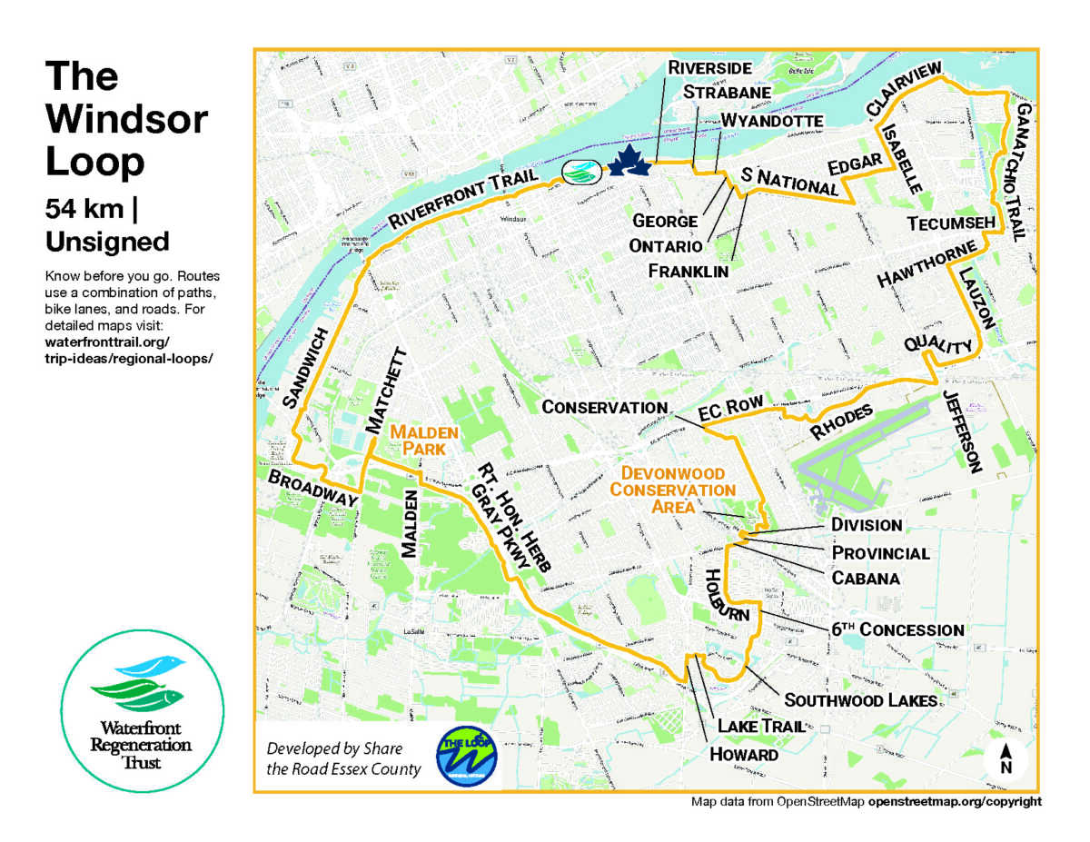
Click here to download the overview map.
Detroit Loop | 40 km, Unsigned
Cross from Windsor into the Motor City—now a city of trails! Ride the Great Lakes Way along Detroit’s revitalized waterfront linking Belle Isle, Eastern Market, and Downriver parks in a vibrant, re-imagined landscape.
Beginning and ending at the Gordie Howe International Bridge gateway, the tour includes several Detroit landmarks including the excellent MexicanTown!
Route developed in collaboration with Detroit Greenway Coalition.
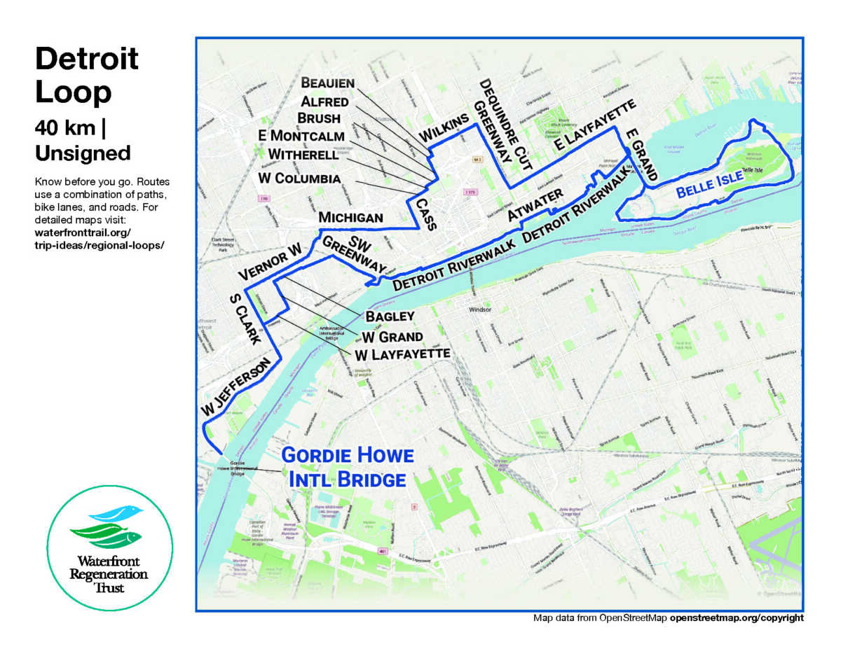
Click here to download the overview map.
West Lake Erie Binational Loop | 356 km, Unsigned
The inaugural binational long-distance cycle route connecting Windsor and Essex County, Point Pelee National Park, Pelee Island, Sandusky, Toledo and Detroit.
Developed in collaboration with the Detroit Greenway Coalition and local communities.
Classic EC Way 100-Mile Century Ride Loop | 163 km, Unsigned
The EC Way 100 is a 100-mile (162 km) circular cycling route connecting Windsor–Essex communities, waterfronts, parks, and key destinations.
Developed through over 20 years of cycling advocacy and municipal collaboration, the route reflects the County of Essex’s vision for a connected, accessible, and enjoyable regional cycling network.
Riders can start anywhere along the loop. From Malden Park (the trailhead to the Gordie Howe International Bridge), the route links many of the region’s most bike-friendly corridors, including connections to the Gordie Howe International Bridge, Great Lakes Waterfront Trail, Trans Canada Trail, and the Kelly-Ann Way—to Point Pelee National Park and mainland Canada’s southernmost point.
Designed with input from experienced local cyclists, the EC Way 100 prioritizes comfort and accessibility—using a mix of multi-use trails, bike lanes, and low-traffic roads to create a safe and scenic experience.
Kelly-Ann Way | 76 km, Unsigned
The Kelly-Ann Way takes you between Windsor/Detroit and Point Pelee National Park by bike. Many years in the making, the route was developed by Share the Road – Essex County in collaboration with local planners and refined with input from many experienced local cyclists. It is widely regarded as one of the most bike-friendly route for road bike riders (with narrow road tires) to reach Point Pelee National Park—mainland Canada’s southernmost point.
The route is named in honour of Windsor-Essex cyclist Kelly-Ann Way: two-time Olympian; Stage Winner in the Tour de France Feminin (1984); and inductee into the Canadian Cycling Hall of Fame.

Cycle Simcoe
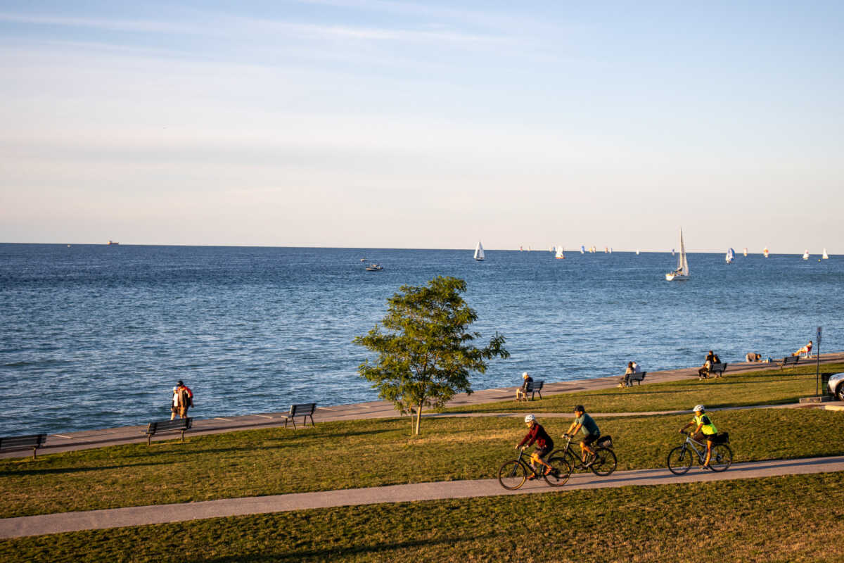
Simcoe County highlights the several cycling routes within the region of Ontario’s Lake Country. From flat and family-friendly routes, to a challenging and hill filled 92k, check out their extensive library of great cycling, many featuring the Great Lakes Waterfront Trail. Simcoe is in South Georgian Bay, located only 90 minutes north of Toronto. Click here for Maps and more information.

Sarnia and Lambton County
Looping through Lambton-on a 3 or 4 day, 166 km, or 262 km (with optional Grand Bend route extension) self-guided trip. Daily Ride Distance Average: 56 km Experience Level: Moderate to experienced. Ride with GPS Routing provided. Developed by Ontario by Bike with support from Ontario’s West Coast.

