• Twitter
  • Facebook
  • Youtube
  • Instagram
  • Twitter
  • Facebook
  • Youtube
  • Instagram
MapsPlease Donate
Great Lakes Waterfront Trail
  • Our Work
    • Overview
    • Pauline Browes Fellowship
    • Publications
    • Our Impact
    • Board & Staff
    • Partners
    • Strategic Plan
  • The Trail
  • Maps
    • Downloadable Maps
    • Interactive Map
    • Trail GPS Data
    • Buy Map
  • Trip Ideas
    • Farm Fresh Tours
    • Featured Trips
    • Great Lakes to Greenbelt
    • 1000km Itinerary
    • Family Friendly Ideas
    • Self-Guided Cycle Tours
    • Regional Loops
    • Cycle + Transit
    • Camping
    • Distance Chart
  • Community Profiles
  • Great Waterfront Trail Adventure
    • GWTA 2025 Overview
    • 2025 Route & Itinerary
    • Registration and Fees
    • Accommodations
    • Fundraising
    • GWTA Volunteer
    • GWTA History
    • GWTA Partners
    • FAQS
  • Donate
  • Media
    • Photos
    • Videos
  • Subscribe
  • Search
  • Menu

Pelee Island

You are here: Home / Community Profiles / Communities / Pelee Island

Pelee is perfect for sun-chasers and stargazers. With lots of Lake Erie shoreline to explore, this is the best of Big Sky and island living. The sunsets can take your breath away.
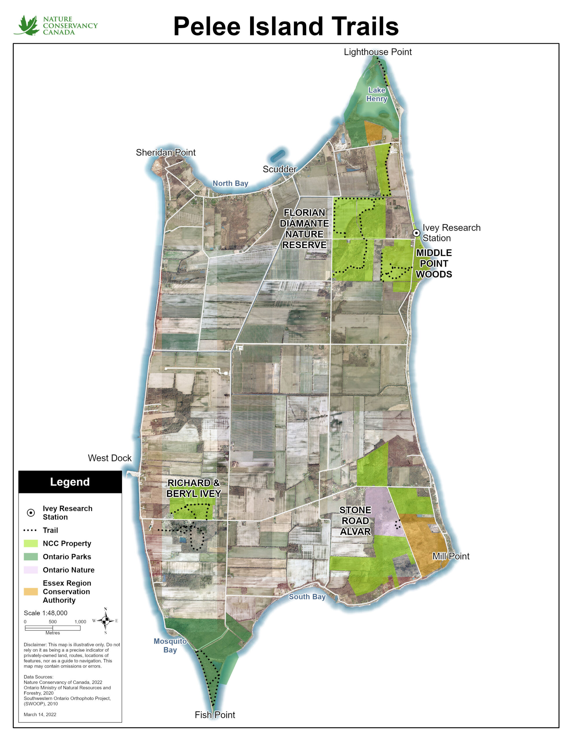
The Pelee Island Waterfront Trail is a 30km circular route, following close to the Lake Erie shoreline all around the Island. The route travels quiet country roads, through farmland, vineyards and natural areas, and has equal sections that are paved and unpaved. The Waterfront Trail also connects to the Islands’s Ecological Trail System, providing access to beaches, forests, sand dunes, marshes and alvars found nowhere else in Canada. It is a wonderful family-friendly week-end getaway!

Pelee Island is located 32 kilometres south of the Ontario mainland and is part of an archipelago of islands in the western Lake Erie basin. This location of Canada’s southernmost inhabited land area (the southernmost point in Canada is found on nearby Middle Island) creates an environment of unique plants and animals and is on major migratory bird and butterfly routes.

The Fish Point Nature Reserve and the Lighthouse Point Nature Reserve provides habitat for rare species including the Blue Racer Snake, Lake Erie Water Snake, Smallmouth Salamander and Spotted Turtle. In addition, 31 provincially rare and 19 regionally rare plant species are located in the reserves. Another unique feature is the Stone Road Alvar, a globally significant area, where you can find plant and animal life that occurs nowhere else in the world. The physical presence of limestone combined with a southerly climate has created a unique Canadian Savannah environment.

The Nature Conservancy of Canada (NCC) has restored protected and continues to manage over 390 hectares (1,000 acres) on Pelee Island including the Florian Diamante Nature Reserve wetland. Be sure to visit the trail and lookout to take in this impressive restoration project.

In addition to the natural heritage features, there are significant cultural heritage features including the Pelee Island Heritage Centre, the Pelee Island Lighthouse, Pelee Island Art Works, the Pelee Island Winery and local limestone architecture. Accommodations on the Island include bed and breakfasts, cottage rentals and camping.

The Pelee Island Waterfront Trail is open all year–accessible by ferry from Spring to late Fall, and by air during winter months. Spring and fall bird and butterfly migrations are favourite times to visit. There is an annual fall pheasant hunt on the Island occurring in part of October and November, when trail users should be cautious.

Pelee Island is a wonderful gateway to Sandusky, Ohio and the American coast of Lake Erie (check out Connecting Trails below for a suggested cycle tour created by Adventure Cyclist.)

Download Printable Map

Pelee Island

Trail Attributes

Distance: 30km

The Trail follows quiet country roads around the outside of the island. Some sections are unpaved.

Bike rentals and ebike rentals are available on the Island.

Access to Island from Ontario and Sandusky Ohio is by Ferry.

Trail Tips:

The Pelee Island route map was recently updated with potable water, hiking, and several restaurants and shopping locations. There are two additional unsigned cycling loops on the island now included on the map: the 19km North Bay Loop and the 8.7km Fish Point Loop.

Do not miss the scenic hikes on the north and south of the island.

Local Maps and ConnectionsStaging AreasAmenities and TransitHelpful Links

Links to Local Maps

Pelee Island Trails Map

Connections

Lake Erie Connector Route — Adventure Cyclist is an American member-based organization that has mapped over 40,000 km of cycling routes in the US. They have a added a number of bi-national and Canadian tours including the Lake Erie Connector route which takes cyclists through Sandusky Ohio and Ontario’s southwest.

Community Links

Township of Pelee

County of Essex

Tourism Windsor Essex Pelee Island

Pelee Island Adventures – for information about e-bike rentals, picnic baskets and tours.

Staging Areas

Access to the Island is via a ferry service

  • Ferry service to Pelee Island is from Kingsville and Leamington Ontario (approximately 1 ½ hours), and from Sandusky Ohio (approximately 1 ¾ hours). For schedules contact Pelee Island Transportation Company (1-800-661-2220) or check their website.

Amenities

  • Accommodations, Campground
  • Accommodations, Roofed
  • Beaches
  • Groceries
  • Hospital
  • LCBO (Includes Breweries and Wineries)
  • Marinas
  • Museums
  • Outfitters
  • Restaurants
  • Shopping Areas
  • Tourist Information
  • Washrooms
  • WIFI
  • Winter Maintenance

Rentals and Ferry Information

• Pelee Island Ferry — Ferry service to Pelee Island is from Kingsville and Leamington Ontario (approximately 1 ½ hours), and from Sandusky Ohio (approximately 1 ¾ hours).

• Pelee Island E-Bike Rentals

• Bike Rentals—The Pelee Shop

Helpful Links

Municipality of Pelee Island

Discover Pelee Island

Tourism Windsor Essex Pelee Island — Things to do and places to visit throughout the Pelee Island, Essex County and Windsor area.

County of Essex

Southwest Ontario Tourism — Great resource for all things to do in Southern Ontario

Ontario By Bike — Itineraries, tours and bike friendly businesses throughout the Province of Ontario.

Nature Conservancy Canada – Learn about the restoration of Florian Diamante Nature Reserve wetland


Protecting. Connecting. Celebrating. The Great Lakes and St. Lawrence River.

The Waterfront Regeneration Trust is a registered charity. Charitable Registration Number: 86767 9821 RR0001
Ontario Trail of Distinction

Newsletter Signup

Address

Select list(s) to subscribe to


By submitting this form, you are consenting to receive marketing emails from: Waterfront Regeneration Trust, 4195 Dundas Street West, Toronto, ON, M8X 1Y4, http://www.waterfronttrail.org. You can revoke your consent to receive emails at any time by using the SafeUnsubscribe® link, found at the bottom of every email. Emails are serviced by Constant Contact

Waterfront Regeneration Trust

4195 Dundas St. West - Suite 327
Toronto, Ontario M8X 1Y4
(416) 943-8080
info@wrtrust.com

Partners Resource Centre

  • 2025 Tourism Workshop Registration
  • Download our Logos
  • Signage Guidelines & Templates
  • Boiler Plate Statements
  • Resources
  • GWTA Participant Surveys
  • State of the Trail
  • 2017 Trail-Wide Partners Meeting
  • 2014 Trail-Wide Partners Meeting
  • Georgian Bay Cycling Route Expansion
  • Lake Superior Expansion
  • Pauline Browes Fellowship
  • Partner Update
  • S-GWTA
© 2018 Great Lakes Waterfront Trail. Made by 9 Lives Design.
  • Twitter
  • Facebook
  • Youtube
  • Instagram
Scroll to top